CARTOSAT-2A
Mission information
- Name
- CARTOSAT-2A
- Satellite ID
- DHND-4474-1527-7198-0174
- NORAD ID
- 32783
- Website
- https://www.isro.gov.in/CARTOSAT_2_PSLVC40.html
- Operator
- ISRO - Indian Space Research Organisation
- Country of Origin
-
India
Status
Operational
Satellite is in orbit and operational
Image
Mission timeline
- Launch Date
- 2008-04-28T00:00:00+00:00
Description
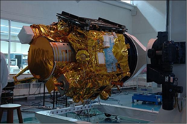
CartoSat 2A is the primary Indian remote sensing craft among the fleet of 10 satellites that were launched by a PSLV 9 rocket from Sriharikota in southeastern coast of India at 03:54 UT on 28 April 2008. The 690 kg, 900 W, triaxially stabilized craft carries a panchromatic camera to provide 0.5-0.85 micron images at one meter resolution in a swath of 9.6 km. It can be steered along track as well as across track to enable repeated images of a chosen site, frequently. The images will be used in rural and urban planning.
SatNOGS Links
Beacon
- Type
- Transmitter
- Downlink Mode
- CW
- Downlink Frequency
- 2245678000
- Downlink Drifted
- 684
Most Recent Observers (last 24h)
No observations recorded for CARTOSAT-2A in the last 24h
Data Frames Decoded - 30 Days
There is no decoded data for this satellite in the last 30
days.
No Decoders Found
Help us develop a decoder, you can find instructions at this wiki link
Orbital Elements
Latest Two-Line Element (TLE)
- TLE Source
- Space-Track.org
- TLE Updated
- 2026-03-31 19:19:51 UTC
- TLE Set
-
1 32783U 08021A   26090.59182666  .00001308  00000-0  18305-3 0  9996
2 32783  97.7734 141.9202 0012099  11.1591 348.9886 14.79142133967339