Suggested Edit for Satellite
Suggested by ENSFNM on: 2021-10-14 00:16
Citation: VK5Q1 and SV1QVE survey
Verdict: Approved
Reviewed by - on: 2021-10-14 08:48
| Name | LEMUR 2 REMY-COLTON |
| NORAD ID | 43884 |
| Followed NORAD ID | - |
| Alternative Names | - |
| Description | Lemur-2 is the initial constellation of low-Earth orbiting satellites built by Spire. These satellites carry two payloads for meteorology and ship traffic tracking. Spire satellites, which orbit close to Earth's atmosphere, use the SENSE payload to listen for GPS satellite signals - which are impacted as they pass through Earth's atmosphere. Using a process called GPS radio occultation, Spire measures the change in GPS signal readings to calculate very precise profiles for temperature, pressure, and humidity here on Earth. The STRATOS payload enables tracking ships worldwide by receiving their AIS signals. It also carries an AirSafe ADS-B payload to track airplanes. |
| Owner/Operator | - |
| Status |
|
| Countries of Origin | |
| Website | - |
| Dashboard URL | - |
| Launch Date | - |
| Deploy Date | - |
| Image | 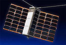 |
| Field | Previous | Suggested |
|---|---|---|
| Description | Lemur-2 is the initial constellation of low-Earth orbiting satellites built by Spire. These satellites carry two payloads for meteorology and ship traffic tracking. Spire satellites, which orbit close to Earth's atmosphere, use the SENSE payload to listen for GPS satellite signals - which are impacted as they pass through Earth's atmosphere. Using a process called GPS radio occultation, Spire measures the change in GPS signal readings to calculate very precise profiles for temperature, pressure, and humidity here on Earth. The STRATOS payload enables tracking ships worldwide by receiving their AIS signals. It also carries an AirSafe ASD-B payload to track airplanes. | Lemur-2 is the initial constellation of low-Earth orbiting satellites built by Spire. These satellites carry two payloads for meteorology and ship traffic tracking. Spire satellites, which orbit close to Earth's atmosphere, use the SENSE payload to listen for GPS satellite signals - which are impacted as they pass through Earth's atmosphere. Using a process called GPS radio occultation, Spire measures the change in GPS signal readings to calculate very precise profiles for temperature, pressure, and humidity here on Earth. The STRATOS payload enables tracking ships worldwide by receiving their AIS signals. It also carries an AirSafe ADS-B payload to track airplanes. |