Suggested Edit for Satellite
Suggested by ENSFNM on: 2021-10-11 20:13
Citation: VK5Q1 and SV1QVE survey
Verdict: Approved
Reviewed by - on: 2021-10-12 07:22
| Name | CARTOSAT 2D |
| NORAD ID | 41948 |
| Followed NORAD ID | - |
| Alternative Names | - |
| Description | Cartosat-2 is an advanced remote sensing satellite with a single panchromatic camera (PAN) capable of providing scene-specific spot imageries for cartographic applications. |
| Owner/Operator | ISRO |
| Status |
|
| Countries of Origin | |
| Website | - |
| Dashboard URL | - |
| Launch Date | Feb. 15, 2017, midnight |
| Deploy Date | - |
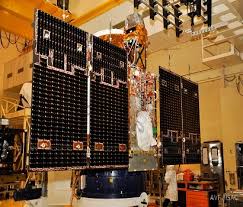
| Image |  |
| Field | Previous | Suggested |
|---|---|---|
| Name | CARTOSAT-2D | CARTOSAT 2D |
| Description | CartoSat 2D is the fifth in India’s second generation of CartoSat Earth Observation craft tasked with the generation of high-resolution imagery, employing a high-degree of agility on the satellites to support event monitoring with high revisit times. The CartoSat-2D launch follows up on the CartoSat-2C mission that launched in June 2016 and is a nearly identical copy of the 2C satellite, carrying the same instruments and operating from a similar orbit. Previous CartoSat missions used a Sun Synchronous Orbit 640 Kilometers in altitude while the newer ones fly at 505 Kilometers in order to increase the resolution of the panchromatic and multispectral cameras aboard the satellites. | Cartosat-2 is an advanced remote sensing satellite with a single panchromatic camera (PAN) capable of providing scene-specific spot imageries for cartographic applications. |
| Owner/Operator | - | ISRO |
| Launch Date | - | Feb. 15, 2017, midnight |
| Image |
|
|